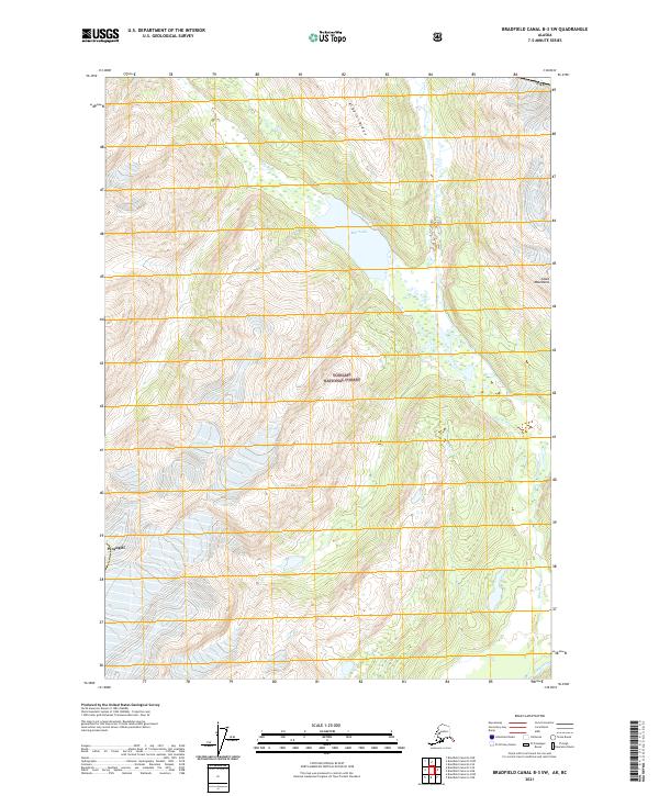
2021 Map of Bradfield Canal B-3 SW
USGS Topo · Published 2021About this map
The Tongass National Forest dominates this Alaskan landscape, where the Coast Mountains meet a complex network of glacial drainage. The center of the sheet is marked by the high-elevation Blue Lake, which feeds into the Blue River as it winds southward. This 2021 survey illustrates the primary topographic features of the region, including the prominent Albert Ridge and the Lava Fork waterway. In the southern reaches, the Unuk River cuts through the terrain, a critical corridor for the region's hydrology. The boundary for Wrangell is also indicated, showing the intersection of municipal interests with the preserved wilderness of the national forest. The map captures the remote character of the international border area, with the Usa line visible in the northeastern corner of the quadrangle.
Find a feature on this map
15 named features on this map. Tap any name to fly to it.
Don’t see what you’re looking for? This feature index may not catch every label — zoom into the map to look around manually.
Map Details
Editions of this 2021 Bradfield Canal B-3 SW Map
This is the sole edition of this map. No revisions or reprints were ever made.
Other maps of this area

1951 · Bradfield Canal
USGS Topo · 1:250,000

1954 · Bradfield Canal
USGS Topo · 1:250,000

1955 · Bradfield canal B-3
USGS Topo · 1:63,360

1955 · Bradfield canal A-4
USGS Topo · 1:63,360

1955 · Bradfield canal B-4
USGS Topo · 1:63,360

1955 · Bradfield canal A-3
USGS Topo · 1:63,360

1955 · Bradfield Canal
USGS Topo · 1:250,000
1995 · Bradfield Canal A-4
USGS Topo · 1:63,360
2017 · Bradfield Canal B-4 NE
USGS Topo · 1:25,000
2017 · Bradfield Canal B-4 SE
USGS Topo · 1:25,000