
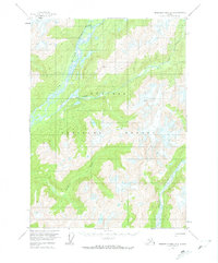
1955 Map of Bradfield canal A-3
USGS Topo · Published 1960About this map
Glacial valleys and high-altitude drainage systems dominate this mid-century survey of the Tongass National Forest. The braided channels of the Unuk River and the Leduc River cut through the terrain, fed by unnamed alpine lakes and high peaks. Evidence of human presence is minimal in this wilderness, though a solitary Cabin is marked in the northern reaches near Sawmill Slough. The mapping relies on aerial photography from 1948, capturing the landscape before the widespread use of modern satellite tracking. Survey markers like Vabm 4138 Lake and Vabm 5681 Jims provide fixed points across the ice-scoured heights. The map also traces the winding course of the Klehini River and Lake Creek, illustrating the complex hydrology of the Alaskan panhandle.
Find a feature on this map
11 named features on this map. Tap any name to fly to it.
Don’t see what you’re looking for? This feature index may not catch every label — zoom into the map to look around manually.
Map Details
Editions of this 1955 Bradfield canal A-3 Map
2 editions found
Other maps of this area

1951 · Bradfield Canal
USGS Topo · 1:250,000

1952 · Ketchikan
USGS Topo · 1:250,000

1954 · Bradfield Canal
USGS Topo · 1:250,000

1955 · Bradfield canal B-2
USGS Topo · 1:63,360

1955 · Ketchikan D-2
USGS Topo · 1:63,360

1955 · Bradfield canal B-3
USGS Topo · 1:63,360

1955 · Bradfield canal A-4
USGS Topo · 1:63,360

1955 · Bradfield canal A-2
USGS Topo · 1:63,360

1955 · Ketchikan D-4
USGS Topo · 1:63,360

1955 · Bradfield canal B-4
USGS Topo · 1:63,360