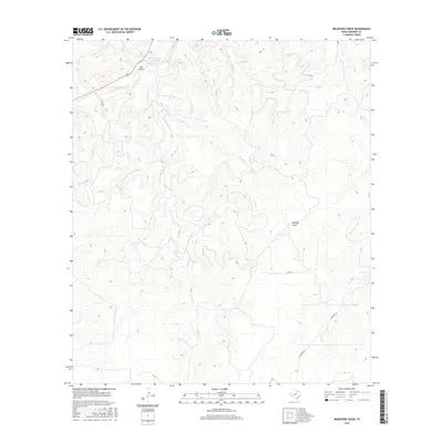
2016 Map of Bradford Creek
USGS Topo · Published 2016About this map
S Llano River tributaries carve through the Edwards County limestone, creating a complex drainage network that defines this part of the Texas Hill Country. The most significant geological landmarks include Blue Hole on the Llano in the north and the extensive branching of Contrary Cr, which includes its W Prong Contrary Cr to the west. This 2016 survey illustrates a landscape primarily shaped by water and elevation, where seasonal runoff paths like Dry Hollow and Beasley Draw cut deep into the terrain. Human presence is limited to rural infrastructure such as Co RD 408, Hackberry Rd, and Mitchell Ln, which navigate the high ridges between the various forks of Bradford Creek and Bluff Cr.
Find a feature on this map
11 named features on this map. Tap any name to fly to it.
Don’t see what you’re looking for? This feature index may not catch every label — zoom into the map to look around manually.
Map Details
Editions of this 2016 Bradford Creek Map
This is the sole edition of this map. No revisions or reprints were ever made.
Other maps of this area

1893 · Rock Springs
USGS Topo · 1:125,000

1926 · Segovia 2-c
USGS Topo · 1:48,000

1932 · Junction
USGS Topo · 1:62,500

1954 · Llano
USGS Topo · 1:250,000

1954 · Sonora
USGS Topo · 1:250,000

1955 · Llano
USGS Topo · 1:250,000

1956 · Llano
USGS Topo · 1:250,000

1958 · Sonora
USGS Topo · 1:250,000

1962 · Hill Ranch
USGS Topo · 1:24,000
1971 · Paint Rock Spring
USGS Topo · 1:24,000