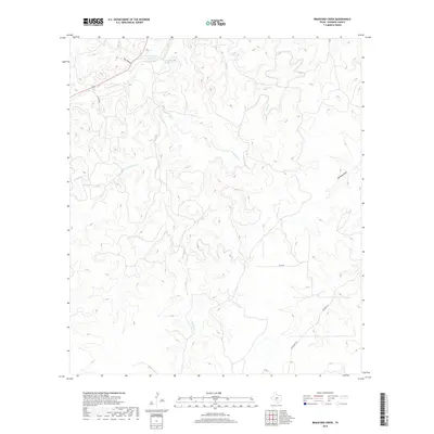
2019 Map of Bradford Creek
USGS Topo · Published 2019About this map
The S Llano River carves through this portion of Edwards County, defining a landscape shaped by intermittent watercourses and significant spring sites. In the northwest corner, the Blue Hole on the Llano serves as a prominent landmark near Dripping Springs, where the river valley is flanked by deep incisions like Dry Hollow. The map reveals a complex drainage network that feeds into the river system from the south and east, including the winding paths of Contrary Cr and its western reach, W Prong Contrary Cr.
Find a feature on this map
15 named features on this map. Tap any name to fly to it.
Don’t see what you’re looking for? This feature index may not catch every label — zoom into the map to look around manually.
Map Details
Editions of this 2019 Bradford Creek Map
This is the sole edition of this map. No revisions or reprints were ever made.
Other maps of this area

1893 · Rock Springs
USGS Topo · 1:125,000

1926 · Segovia 2-c
USGS Topo · 1:48,000

1932 · Junction
USGS Topo · 1:62,500

1954 · Llano
USGS Topo · 1:250,000

1954 · Sonora
USGS Topo · 1:250,000

1955 · Llano
USGS Topo · 1:250,000

1956 · Llano
USGS Topo · 1:250,000

1958 · Sonora
USGS Topo · 1:250,000

1962 · Hill Ranch
USGS Topo · 1:24,000
1971 · Paint Rock Spring
USGS Topo · 1:24,000