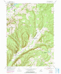
1953 Map of Bradford
USGS Topo · Published 1991About this map
Bradford and Monterey anchor this mid-century topographic portrait of the Schuyler and Steuben county borderlands. The landscape is defined by the winding course of Pine Creek and Meads Creek, where small settlements and rural homesteads follow the valley floors between steep ridgelines. The map reveals a deeply rooted community infrastructure, documented through numerous family and local burying grounds such as Old Sugar Hill Cem, Maltby Cem, and Christ Johns Cem. Education in this rural pocket of Orange and Hornby was localized at the time of the original 1953 survey, evidenced by the Star District Sch and District No 1 Sch. From the waters of Cinnamon Lake in the east to the Mill Pond in the north, the map captures the transition from post-war agricultural life into the late 20th century, with later revisions in purple indicating woodland shifts and minor cultural updates.
Find a feature on this map
23 named features on this map. Tap any name to fly to it.
Don’t see what you’re looking for? This feature index may not catch every label — zoom into the map to look around manually.
Map Details
Editions of this 1953 Bradford Map

Other maps of this area

1895 · Elmira
USGS Topo · 1:62,500

1898 · Watkins Glen
USGS Topo · 1:62,500

1901 · Watkins
USGS Topo · 1:62,500

1903 · Hammondsport
USGS Topo · 1:62,500

1905 · Watkins Glen
USGS Topo · 1:125,000

1914 · Corning
USGS Topo · 1:62,500

1944 · Corning
USGS Topo · 1:62,500

1950 · Elmira
USGS Topo · 1:250,000
1950 · Reading Center
USGS Topo · 1:24,000
1953 · Wayne
USGS Topo · 1:24,000