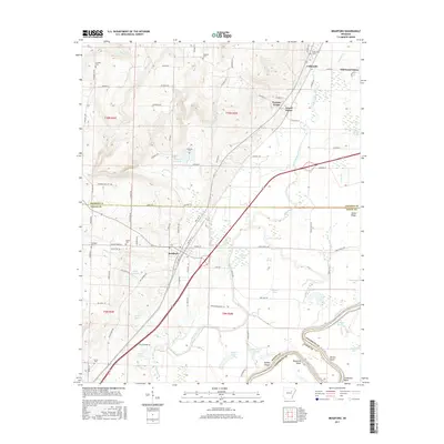
2017 Map of Bradford
USGS Topo · Published 2017About this map
The settlement of Bradford anchors this landscape in White County, situated where the Arkansas lowlands meet the rising hills to the west. A complex drainage system defines the area, with Departee Creek and Butter Cr meandering toward the White River at the southern boundary. Along the river, distinctive navigation landmarks such as Blackbird Bend, Dudley Dread, and Cocklebur Bend trace the water's winding path through the bottomlands. To the north, the small communities of Grand Glaise and Possum Grape sit along the highway corridor.
Find a feature on this map
97 named features on this map. Tap any name to fly to it.
Don’t see what you’re looking for? This feature index may not catch every label — zoom into the map to look around manually.
Map Details
Editions of this 2017 Bradford Map
This is the sole edition of this map. No revisions or reprints were ever made.
Other maps of this area

1890 · Batesville
USGS Topo · 1:125,000

1891 · Batesville
USGS Topo · 1:125,000

1935 · Newport
USGS Topo · 1:62,500

1935 · Augusta
USGS Topo · 1:62,500

1935 · Bald Knob
USGS Topo · 1:62,500

1953 · Memphis
USGS Topo · 1:250,000

1956 · Memphis
USGS Topo · 1:250,000

1957 · Augusta
USGS Topo · 1:62,500
1962 · Olyphant
USGS Topo · 1:24,000

1962 · Newport
USGS Topo · 1:24,000