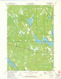
1971 Map of Bradley
USGS Topo · Published 1973About this map
Lake Nokomis and the Little Rice River Flowage dominate this northern Wisconsin landscape at the border of Oneida and Lincoln Counties. The 1971 survey illustrates a region defined by extensive water management and flowage systems, where the Little Rice River and Somo River feed into larger reservoirs. The settlement of Bradley sits at a critical junction of the Soo Line railroad and local transport routes like Milky Rd. Moving away from the populated corridors, the map reveals a network of fire lanes and rural drives, such as Kelly Fire Lane and Rozell Drive, winding through swampy terrain and smaller water bodies like Killarney Lake and Prairie Lake. Genealogists may find interest in the Prairie Rapids Cem located near the eastern edge, while the various town hall locations and the Wayside Park mark the social and civic center of these lakeside communities during the early 1970s.
Find a feature on this map
34 named features on this map. Tap any name to fly to it.
Don’t see what you’re looking for? This feature index may not catch every label — zoom into the map to look around manually.
Map Details
Editions of this 1971 Bradley Map
This is the sole edition of this map. No revisions or reprints were ever made.
Other maps of this area

1939 · Mc Cord
USGS Topo · 1:48,000

1939 · Cassian
USGS Topo · 1:48,000

1942 · Cassian
USGS Topo · 1:48,000

1947 · Mc Cord
USGS Topo · 1:48,000

1950 · Tomahawk
USGS Topo · 1:48,000

1950 · Spirit Falls
USGS Topo · 1:48,000

1952 · Spirit Falls
USGS Topo · 1:48,000

1952 · Tomahawk
USGS Topo · 1:48,000

1954 · Iron Mountain
USGS Topo · 1:250,000

1959 · Iron Mountain
USGS Topo · 1:250,000