
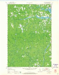
1950 Map of Spirit Falls
USGS Topo · Published 1957About this map
The Spirit River and Wisconsin River dominate this mid-century survey of Lincoln County, where the transition from industrial logging to managed forest is visible in the landscape. Significant river infrastructure appears at Grandfather Falls, where the Grandfather Dam and Power Plant harness the current. The map documents numerous remote outpost camps like Natzke Camp, Camp 25, and Camp 27, alongside small centers like Spirit Falls and New Wood.
Find a feature on this map
46 named features on this map. Tap any name to fly to it.
Don’t see what you’re looking for? This feature index may not catch every label — zoom into the map to look around manually.
Map Details
Editions of this 1950 Spirit Falls Map
2 editions found
Other maps of this area

1899 · Wausau
USGS Topo · 1:125,000

1902 · Wausau
USGS Topo · 1:125,000

1902 · Marathon
USGS Topo · 1:125,000

1939 · Mc Cord
USGS Topo · 1:48,000

1939 · Cassian
USGS Topo · 1:48,000

1941 · Brantwood
USGS Topo · 1:48,000

1942 · Cassian
USGS Topo · 1:48,000

1943 · Brantwood
USGS Topo · 1:48,000

1945 · Rib Lake
USGS Topo · 1:48,000

1947 · Mc Cord
USGS Topo · 1:48,000