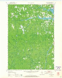
1950 Map of Spirit Falls
USGS Topo · Published 1966About this map
Spirit Falls serves as a primary hub in this mid-century landscape, where the Somo River and Spirit River Flowage dominate the northern terrain. The area reflects a transition from early industrial logging to a more settled rural character, evidenced by numerous school sites like Mitchell Sch and the abandoned Gladfelter Sch. To the south, the Wisconsin River carves through the landscape, featuring the Grandfather Dam and its associated Power Plant, highlighting the region's hydro-electric development. The map reveals an intricate network of forestry infrastructure, including a lengthy Fire Lane and several camps such as Natzke Camp and Camp 25. These features, alongside the Old Railroad Grade, point to a history of timber extraction that shaped the townships of Somo, Wilson, and Harding.
Find a feature on this map
51 named features on this map. Tap any name to fly to it.
Don’t see what you’re looking for? This feature index may not catch every label — zoom into the map to look around manually.
Map Details
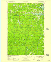
Editions of this 1950 Spirit Falls Map
2 editions found
Other maps of this area

1899 · Wausau
USGS Topo · 1:125,000

1902 · Wausau
USGS Topo · 1:125,000

1902 · Marathon
USGS Topo · 1:125,000

1939 · Mc Cord
USGS Topo · 1:48,000

1939 · Cassian
USGS Topo · 1:48,000

1941 · Brantwood
USGS Topo · 1:48,000

1942 · Cassian
USGS Topo · 1:48,000
1943 · Brantwood
USGS Topo · 1:48,000

1945 · Rib Lake
USGS Topo · 1:48,000

1947 · Mc Cord
USGS Topo · 1:48,000