
1903 Map of Bradshaw Mountains
USGS Topo · Published 1903About this map
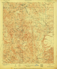
Prescott Forest Reserve dominates this high-country landscape, where the early 20th-century mining economy is etched into the rugged topography of the Bradshaw Mountains. The central spine of the range is dotted with industrial landmarks such as the Valverde Smelter and Boggs Smelter, supported by a network of mills including the Stormcloud Mill and Tuscumbia Mill. Transport is anchored by the Prescott and Eastern R.R., which snakes through the eastern foothills toward Mayer. This survey records a transition period for the territory, illustrating the density of family-named outposts and remote settlements like Crown King, Minnehaha, and Tiptop. In the south, the terrain drops toward the Agua Fria River and the Yavapai Co. Maricopa Co. boundary line, marking the limit of the mountain mining districts.
Find a feature on this map
131 named features on this map. Tap any name to fly to it.
Don’t see what you’re looking for? This feature index may not catch every label — zoom into the map to look around manually.
Map Details
Editions of this 1903 Bradshaw Mountains Map
4 editions found
Other maps of this area

1887 · Verde
USGS Topo · 1:250,000

1887 · Prescott
USGS Topo · 1:250,000

1892 · Verde
USGS Topo · 1:250,000

1892 · Prescott
USGS Topo · 1:250,000

1903 · Congress
USGS Topo · 1:125,000

1904 · Congress
USGS Topo · 1:125,000

1905 · Jerome
USGS Topo · 1:125,000

1923 · Camp Verde
USGS Topo · 1:125,000

1929 · Turret Peak
USGS Topo · 1:125,000

1930 · Cave Creek
USGS Topo · 1:125,000