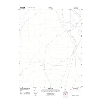
2012 Map of Bradshaw Spring
USGS Topo · Published 2012About this map
Bradshaw Spring and several other groundwater sources define this desert landscape in Nye County, Nevada. The presence of Indian Spring and Leoman Spring suggests a reliance on traditional water points in an otherwise arid environment. Settlement is sparse, represented primarily by the Bradshaw Ranch, which sits at a junction of regional roads. The northeast corner of the map features the vital northern reach of Duckwater Creek and the Duckwater Airport, providing essential transportation links for this isolated high-desert valley. The map documents the persistent human footprint of ranching and aviation in a region where geography is largely dictated by water availability.
Find a feature on this map
6 named features on this map. Tap any name to fly to it.
Don’t see what you’re looking for? This feature index may not catch every label — zoom into the map to look around manually.
Map Details
Editions of this 2012 Bradshaw Spring Map
This is the sole edition of this map. No revisions or reprints were ever made.
Other maps of this area

1956 · Lund
USGS Topo · 1:250,000

1960 · Lund
USGS Topo · 1:250,000

1964 · Blue Eagle Springs
USGS Topo · 1:62,500

1964 · Duckwater
USGS Topo · 1:62,500

1968 · Portuguese Mtn
USGS Topo · 1:62,500

1968 · Brown Summit
USGS Topo · 1:24,000
1968 · Sand Spring
USGS Topo · 1:24,000

1968 · Portuguese Mtn
USGS Topo · 1:24,000

1980 · Duckwater
USGS Topo · 1:100,000
1990 · Bradshaw Spring
USGS Topo · 1:24,000