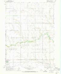
1969 Map of Bradshaw
USGS Topo · Published 1971About this map
Bradshaw serves as the primary hub of this eastern Nebraska agricultural landscape, positioned along the Burlington Northern railroad corridor. The area is defined by the steady, meandering path of Lincoln Creek and its tributary, Coon Branch, which drain the surrounding prairie. These watercourses dictate the placement of local landmarks like the Lincoln Creek Cem and Bethesda Cem, while the township boundaries of Arborville, Morton, Bradshaw, and Lockridge partition the productive grain fields. A notable density of labels marked Well across the sections highlights the intensive groundwater management required for regional farming. The map also documents the municipal infrastructure of the era, including the Sewage Disposal Ponds located just south of the town center, providing a detailed look at the rural-industrial interface during the late 1960s.
Find a feature on this map
12 named features on this map. Tap any name to fly to it.
Don’t see what you’re looking for? This feature index may not catch every label — zoom into the map to look around manually.
Map Details
Editions of this 1969 Bradshaw Map
This is the sole edition of this map. No revisions or reprints were ever made.
Other maps of this area

1896 · Stromsburg
USGS Topo · 1:125,000

1898 · York
USGS Topo · 1:125,000

1899 · York
USGS Topo · 1:125,000

1955 · Fremont
USGS Topo · 1:250,000

1955 · Lincoln
USGS Topo · 1:250,000

1957 · Fremont
USGS Topo · 1:250,000

1957 · Lincoln
USGS Topo · 1:250,000

1958 · Fremont
USGS Topo · 1:250,000

1958 · Lincoln
USGS Topo · 1:250,000

1962 · Polk
USGS Topo · 1:24,000