
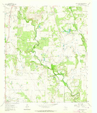
1925 Map of Brady 1-b
USGS Topo · Published 1925About this map
The Colorado River carves a deep path through Central Texas in this mid-1920s survey, marking the intersection of McCulloch, Coleman, and Brown counties. The settlement of Mercury serves as a local hub along the Rio Grande Highway, which runs parallel to the railroad lines of the Ft Worth and State systems. The terrain is defined by prominent elevations such as Morgen Mtn and Lost Mtn, surrounded by a complex network of drainage including Mc Dowell Creek, Chamberlain Creek, and the Crooked Branch. This map, based in part on early aerial photography by the U.S. Army Air Service, documents the landscape before the widespread development of modern reservoirs, showing the natural course of the river and the established ranching and rail infrastructure that supported early 20th-century life in the region.
Find a feature on this map
20 named features on this map. Tap any name to fly to it.
Don’t see what you’re looking for? This feature index may not catch every label — zoom into the map to look around manually.
Map Details
Editions of this 1925 Brady 1-b Map
This is the sole edition of this map. No revisions or reprints were ever made.
Other maps of this area

1887 · Coleman
USGS Topo · 1:125,000

1889 · Coleman
USGS Topo · 1:125,000

1894 · Brady
USGS Topo · 1:125,000

1924 · Brady 2-a
USGS Topo · 1:48,000

1925 · Brady 1-a
USGS Topo · 1:48,000

1928 · Mercury
USGS Topo · 1:62,500

1928 · Waldrip
USGS Topo · 1:62,500

1950 · Mercury
USGS Topo · 1:62,500

1954 · Brownwood
USGS Topo · 1:250,000
1962 · Speck Mountain
USGS Topo · 1:24,000