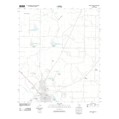
2010 Map of Brady North
USGS Topo · Published 2010About this map
Brady serves as the focal point of this Central Texas landscape, situated just south of the rising Brady Mountains. The town's grid is bounded by Brady Creek and the Richards Park Reservoir, illustrating a community deeply connected to its water resources. North of the city, the terrain is defined by an extensive network of water management projects, including Gene Naumann Lake 1 and several Soil Conservation Service reservoirs such as Site 45 Reservoir. Local history and aviation are noted at Brady Curtis Field, while recreational and social spaces like the Jubilee Racetrack and Rest Haven Cemetery provide a more intimate look at the local geography. The map also captures smaller peripheral settlements and crossroads like East Sweden and Paul Junction, which emphasize the rural connectivity of McCulloch County during this era.
Find a feature on this map
45 named features on this map. Tap any name to fly to it.
Don’t see what you’re looking for? This feature index may not catch every label — zoom into the map to look around manually.
Map Details
Editions of this 2010 Brady North Map
This is the sole edition of this map. No revisions or reprints were ever made.
Other maps of this area

1894 · Brady
USGS Topo · 1:125,000

1928 · Mercury
USGS Topo · 1:62,500

1928 · Waldrip
USGS Topo · 1:62,500

1950 · Mercury
USGS Topo · 1:62,500

1954 · Brownwood
USGS Topo · 1:250,000

1960 · West Sweden
USGS Topo · 1:24,000

1960 · Brady North
USGS Topo · 1:24,000
1963 · Voca
USGS Topo · 1:24,000
1963 · Rochelle
USGS Topo · 1:24,000

1963 · Brady SW
USGS Topo · 1:24,000