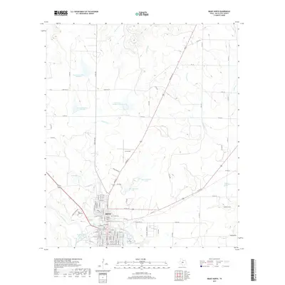
2019 Map of Brady North
USGS Topo · Published 2019About this map
Brady stands as the central hub in this McCulloch County landscape, where the convergence of various ranch roads and state routes meets the waters of Brady Creek. The city's northern reaches are defined by a network of water management and local landmarks, including the aviation history of Curtis Field and several numbered reservoirs such as Reservoir Number Fortysix. To the west, Rest Haven Cem and Live Oak Cem provide essential locations for genealogical research, situated near the banks of Live Oak Cr. The topography transitions from the urban street grid of Brady into the undulating terrain of the Edwards Plateau, marked by features like Sweden Hollow and Bryson Hill. Historically significant water sources, notably the Soldiers Water Hole Spring, reflect the enduring importance of water in this semi-arid region of Central Texas.
Find a feature on this map
95 named features on this map. Tap any name to fly to it.
Don’t see what you’re looking for? This feature index may not catch every label — zoom into the map to look around manually.
Map Details
Editions of this 2019 Brady North Map
This is the sole edition of this map. No revisions or reprints were ever made.
Other maps of this area

1894 · Brady
USGS Topo · 1:125,000

1928 · Mercury
USGS Topo · 1:62,500

1928 · Waldrip
USGS Topo · 1:62,500

1950 · Mercury
USGS Topo · 1:62,500

1954 · Brownwood
USGS Topo · 1:250,000

1960 · West Sweden
USGS Topo · 1:24,000

1960 · Brady North
USGS Topo · 1:24,000
1963 · Voca
USGS Topo · 1:24,000
1963 · Rochelle
USGS Topo · 1:24,000

1963 · Brady SW
USGS Topo · 1:24,000