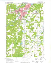
1973 Map of Brainerd
USGS Topo · Published 1976About this map
The Mississippi River defines the western edge of Brainerd in the mid-1970s, where the city's growth is marked by the sprawling complex of the Brainerd State Hospital and the development of the Brainerd Mall. The town's institutional history is well-documented through numerous neighborhood schools like Garfield Sch and Edison Sch, alongside the Brainerd Jr College campus. The rail economy remains visible with the Burlington Northern lines serving the regional trade center.
Find a feature on this map
51 named features on this map. Tap any name to fly to it.
Don’t see what you’re looking for? This feature index may not catch every label — zoom into the map to look around manually.
Map Details
Editions of this 1973 Brainerd Map
2 editions found
Other maps of this area

1915 · Brainerd
USGS Topo · 1:62,500

1916 · Pillager
USGS Topo · 1:62,500

1918 · Brainerd
USGS Topo · 1:62,500

1919 · Pillager
USGS Topo · 1:62,500

1948 · Belle Prairie
USGS Topo · 1:62,500

1948 · Lastrup
USGS Topo · 1:62,500

1950 · Lastrup
USGS Topo · 1:62,500

1950 · Belle Prairie
USGS Topo · 1:62,500

1953 · Brainerd
USGS Topo · 1:250,000

1954 · Baxter
USGS Topo · 1:24,000
Featured Places
- Brainerd, MN
- Baxter, MN
- Meadow View Manor, Brainerd
- Westwood Mobile Home Park, Brainerd
- East Gate Mobile Home Park, Brainerd