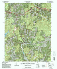
1993 Map of Branchville
USGS Topo · Published 1996About this map
Hoosier National Forest land dominates this section of southern Indiana, where deep valleys and ridges define the landscape of the Leopold Unit. Small settlements such as Saint Croix, Branchville, and Doolittle Mills are scattered across the drainage basins of the Anderson River and Oil Creek. The presence of the Branchville Correctional Center and several recreation areas around Lake Celina and Indian Lake illustrate the mid-20th-century shift toward institutional and recreational land use in these former timberlands. Genealogists will find a significant number of family-named burial sites, including the Rickenbaugh Cem, Woolums Cem, and Frakes Cem, many of which are tucked away on high ground like German Ridge and Fairview Ridge. The map also clearly delineates the Purchase Unit Boundary and the line between Perry and Crawford Counties.
Find a feature on this map
45 named features on this map. Tap any name to fly to it.
Don’t see what you’re looking for? This feature index may not catch every label — zoom into the map to look around manually.
Map Details
Editions of this 1993 Branchville Map
This is the sole edition of this map. No revisions or reprints were ever made.
Other maps of this area

1950 · Beechwood
USGS Topo · 1:24,000

1950 · English
USGS Topo · 1:24,000

1950 · Alton
USGS Topo · 1:62,500

1950 · Alton
USGS Topo · 1:24,000

1951 · Alton
USGS Topo · 1:24,000

1954 · Derby
USGS Topo · 1:24,000

1956 · Taswell
USGS Topo · 1:24,000

1956 · Vincennes
USGS Topo · 1:250,000

1957 · Vincennes
USGS Topo · 1:250,000

1957 · Birdseye
USGS Topo · 1:24,000