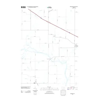
2013 Map of Brandon
USGS Topo · Published 2013About this map
The Cedar River flows through this Eastern Iowa landscape, creating a meandering boundary near the small community of Brandon. In the early 21st century, the area maintains its rural character with a grid of country roads such as S Blackhawk Buchanan Ave and Wellman Rd connecting scattered settlements. To the south, Mount Auburn sits near the riverbanks, where the Mount Auburn Bridge facilitates travel across the water. The drainage basin is defined by several tributaries, including Lime Creek, Mud Creek, and Spring Creek, which weave through the agricultural parcels. The tiny hamlet of Sunny Side occupies a quiet position east of the main river valley, while the interstate corridor cuts diagonally across the northern portion of the quadrangle, illustrating the modern transport network's overlay on the traditional riverine landscape.
Find a feature on this map
68 named features on this map. Tap any name to fly to it.
Don’t see what you’re looking for? This feature index may not catch every label — zoom into the map to look around manually.
Map Details
Editions of this 2013 Brandon Map
This is the sole edition of this map. No revisions or reprints were ever made.
Other maps of this area

1888 · Shellsburg
USGS Topo · 1:62,500

1889 · Shellsburg
USGS Topo · 1:62,500

1899 · Shellsburg
USGS Topo · 1:62,500

1903 · Winthrop
USGS Topo · 1:125,000

1954 · Waterloo
USGS Topo · 1:250,000

1955 · Waterloo
USGS Topo · 1:250,000

1959 · Dubuque
USGS Topo · 1:250,000

1961 · Dubuque
USGS Topo · 1:250,000

1962 · Dubuque
USGS Topo · 1:250,000
1968 · Center Point NW
USGS Topo · 1:24,000