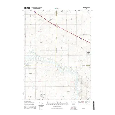
2015 Map of Brandon
USGS Topo · Published 2015About this map
The Cedar River carves a wide path through the southern half of this landscape, anchoring the rural communities of Brandon and Mount Auburn. This mid-2010s survey reveals a landscape defined by its waterways and the structured grid of Iowa's sectional farming history, where the river's path is marked by the Mount Auburn Bridge and surrounding wetlands. Genealogy and local history researchers can identify established family-linked sites such as the Spring Creek Cem located north of Brandon, along with the network of creeks like Spring Creek and Mud Cr that drain the fertile agricultural plains. The presence of Interstate 380 cutting diagonally across the northern section illustrates the modern transportation corridor that connects these small river towns to the broader region while they maintain their distinct local identities.
Find a feature on this map
61 named features on this map. Tap any name to fly to it.
Don’t see what you’re looking for? This feature index may not catch every label — zoom into the map to look around manually.
Map Details
Editions of this 2015 Brandon Map
This is the sole edition of this map. No revisions or reprints were ever made.
Other maps of this area

1888 · Shellsburg
USGS Topo · 1:62,500

1889 · Shellsburg
USGS Topo · 1:62,500

1899 · Shellsburg
USGS Topo · 1:62,500

1903 · Winthrop
USGS Topo · 1:125,000

1954 · Waterloo
USGS Topo · 1:250,000

1955 · Waterloo
USGS Topo · 1:250,000

1959 · Dubuque
USGS Topo · 1:250,000

1961 · Dubuque
USGS Topo · 1:250,000

1962 · Dubuque
USGS Topo · 1:250,000
1968 · Center Point NW
USGS Topo · 1:24,000