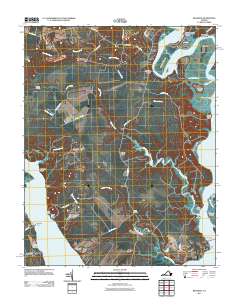
2011 Map of Brandon
USGS Topo · Published 2011About this map
The Row and the historic riverfront properties of Brandon define this Tidewater landscape where the James River and Chickahominy River converge. The area is characterized by centuries-old landholdings and small settlements like Cherry Hall and Oldfield, connected by a network of rural roads such as Wilcox Neck Rd and The Glebe Ln. Waterfront activity is evident at Ritchie Wharf and Brickyard Landing, while the interior shows the drainage patterns of Tomahund Creek and Morris Creek. Genealogists may find value in the location of the Brandon Plantation Cemetery, which sits near the southern bank of the James. The topography reveals the complex shoreline of Bush Neck and Big Marsh Point, illustrating the persistent relationship between these agricultural lands and the tidal waters of coastal Virginia.
Find a feature on this map
55 named features on this map. Tap any name to fly to it.
Don’t see what you’re looking for? This feature index may not catch every label — zoom into the map to look around manually.
Map Details
Editions of this 2011 Brandon Map
This is the sole edition of this map. No revisions or reprints were ever made.
Other maps of this area

1917 · Toano
USGS Topo · 1:62,500

1918 · Charles City
USGS Topo · 1:62,500

1918 · Toano
USGS Topo · 1:62,500

1919 · Surry
USGS Topo · 1:62,500

1919 · Disputanta
USGS Topo · 1:62,500

1943 · Savedge
USGS Topo · 1:31,680

1943 · Richmond
USGS Topo · 1:250,000

1949 · Richmond
USGS Topo · 1:250,000
1952 · Brandon
USGS Topo · 1:24,000
1952 · Norge
USGS Topo · 1:24,000