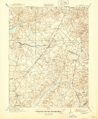
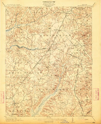
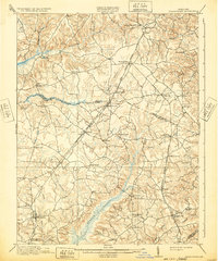
1913 Map of Brandywine
USGS Topo · Published 1946About this map
La Plata and the neighboring Southern Maryland countryside are depicted here following culture revisions in 1900 and 1911. The landscape is defined by the significant wetlands of Zekiah Swamp and Merrick Swamp, which dictate the placement of early settlements and road networks. The economic and social life of the region is anchored by scattered rural hubs such as Brandywine, Cheltenham, and Hughesville, alongside localized landmarks like Burnt Store and the Reform School.
Find a feature on this map
56 named features on this map. Tap any name to fly to it.
Don’t see what you’re looking for? This feature index may not catch every label — zoom into the map to look around manually.
Map Details
Editions of this 1913 Brandywine Map
3 editions found
Other maps of this area

1889 · Fredericksburg
USGS Topo · 1:125,000

1890 · Mt. Vernon
USGS Topo · 1:125,000

1891 · Mt. Vernon
USGS Topo · 1:125,000

1892 · Leonardtown
USGS Topo · 1:62,500

1892 · Fredericksburg
USGS Topo · 1:125,000

1892 · Prince Frederick
USGS Topo · 1:62,500

1892 · Brandywine
USGS Topo · 1:62,500

1892 · Owensville
USGS Topo · 1:62,500

1894 · Wicomico
USGS Topo · 1:62,500

1894 · Fredericksburg
USGS Topo · 1:125,000