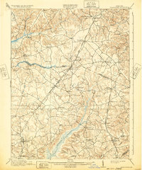
1913 Map of Brandywine
USGS Topo · Published 1932About this map
The rolling hills and tobacco lands of Prince George’s and Charles Counties are captured here as they appeared after the turn of the century. This landscape is defined by its early transit corridors, specifically the Philadelphia Baltimore and Washington and the Chesapeake and Potomac railroads, which facilitated the movement of goods through junctions like Waldorf and the Malcolm Woodville Sta. These rail lines weave through a network of small, rural hamlets such as Gallant Green, T B, and Brandywine.
Find a feature on this map
58 named features on this map. Tap any name to fly to it.
Don’t see what you’re looking for? This feature index may not catch every label — zoom into the map to look around manually.
Map Details
Editions of this 1913 Brandywine Map
3 editions found
Other maps of this area

1889 · Fredericksburg
USGS Topo · 1:125,000

1890 · Mt. Vernon
USGS Topo · 1:125,000

1891 · Mt. Vernon
USGS Topo · 1:125,000

1892 · Leonardtown
USGS Topo · 1:62,500

1892 · Fredericksburg
USGS Topo · 1:125,000

1892 · Prince Frederick
USGS Topo · 1:62,500

1892 · Brandywine
USGS Topo · 1:62,500

1892 · Owensville
USGS Topo · 1:62,500

1894 · Wicomico
USGS Topo · 1:62,500

1894 · Fredericksburg
USGS Topo · 1:125,000