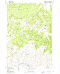
1967 Map of Brannan Gulch
USGS Topo · Published 1980About this map
Whitman National Forest dominates this Baker County landscape, where the terrain is defined by a dense network of gulches and creeks feeding toward the Burnt River in the south. The 1960s survey records a high-elevation environment marked by prominent peaks such as Bald Mtn and Little Bald Mtn. The area's extraction history is visible through numerous prospects and mines scattered across the slopes, including the named Elliot Mine located near Brannan Gulch. A complex system of drainage includes Black Mountain Creek, Pine Creek, and Cornet Creek, illustrating the watershed patterns of the Blue Mountains region. Navigability during this era was limited to an intricate web of a Jeep Trail and a Trail network, reflecting the remote nature of the forest interior and the difficulty of accessing these mining and grazing lands.
Find a feature on this map
35 named features on this map. Tap any name to fly to it.
Don’t see what you’re looking for? This feature index may not catch every label — zoom into the map to look around manually.
Map Details
Editions of this 1967 Brannan Gulch Map
3 editions found
Other maps of this area

1901 · Baker City
USGS Topo · 1:125,000

1901 · Sumpter
USGS Topo · 1:125,000

1908 · Ironside Mountain
USGS Topo · 1:125,000

1955 · Baker
USGS Topo · 1:250,000

1955 · Canyon City
USGS Topo · 1:250,000

1959 · Baker
USGS Topo · 1:250,000

1959 · Canyon City
USGS Topo · 1:250,000

1964 · Ironside
USGS Topo · 1:62,500

1967 · Dooley Mtn
USGS Topo · 1:24,000

1967 · Blue Canyon
USGS Topo · 1:24,000