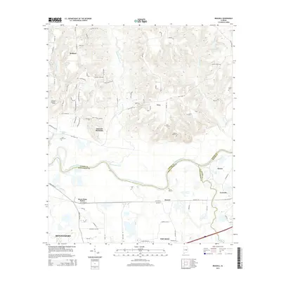
2014 Map of Brassell
USGS Topo · Published 2014About this map
Chubbehatchee Creek winds southward through the center of this landscape, eventually meeting the Tallapoosa River as it forms the boundary between Elmore, Montgomery, and Macon counties. The map documents a blend of expanding residential development around Emerald Mountain and Redland in the north, contrasted with the more traditional rural settlement patterns further south. Genealogists will find a significant density of family and community burial grounds, including the Billingslea Cem, Strahan Cem, and the Wares Quarter Cem near Ware. The southern portion of the quadrangle is defined by the rail corridor at Mount Meigs Station and the crossroad communities of Brassell and Tysonville, where the land flattens as it approaches Line Creek. Small local landmarks like the Emerald Mountain Airport and water bodies such as Poundstone Lake dot the terrain, illustrating the modern character of this transitional Alabama landscape.
Find a feature on this map
80 named features on this map. Tap any name to fly to it.
Don’t see what you’re looking for? This feature index may not catch every label — zoom into the map to look around manually.
Map Details
Editions of this 2014 Brassell Map
This is the sole edition of this map. No revisions or reprints were ever made.
Other maps of this area

1901 · Wetumpka
USGS Topo · 1:125,000

1901 · Wetumpka
USGS Topo · 1:62,500

1903 · Wetumpka
USGS Topo · 1:125,000

1906 · Dadeville
USGS Topo · 1:125,000

1953 · Montgomery
USGS Topo · 1:250,000

1955 · Phenix City
USGS Topo · 1:250,000

1956 · Montgomery
USGS Topo · 1:250,000

1957 · Phenix City
USGS Topo · 1:250,000

1957 · Montgomery
USGS Topo · 1:250,000

1958 · Phenix City
USGS Topo · 1:250,000