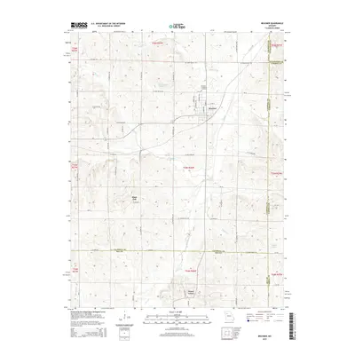
2015 Map of Braymer
USGS Topo · Published 2015About this map
Braymer sits at the convergence of several county boundaries, serving as a hub for the surrounding agricultural landscape of Caldwell, Carroll, and Ray Counties. The town's layout is defined by its residential streets like N Main St and E 6th St, with the Braymer Evergreen Cemetery located just to the north. Outside the main settlement, the terrain is shaped by a dense network of tributaries, including N Mud Cr, Dead Oak Br, and Willow Cr, which drain into the larger Mud Cr. Scattered hamlets and historical points of interest such as Black Oak to the west and Tinney Grove to the south illustrate the enduring pattern of rural Missouri settlements. Landowners and researchers can trace local landmarks like Hughson Lake and Martin Lake Section 4, alongside a grid of secondary routes like SE Mud Creek Dr that link these isolated farmsteads.
Find a feature on this map
67 named features on this map. Tap any name to fly to it.
Don’t see what you’re looking for? This feature index may not catch every label — zoom into the map to look around manually.
Map Details
Editions of this 2015 Braymer Map
This is the sole edition of this map. No revisions or reprints were ever made.
Other maps of this area

1889 · Lexington
USGS Topo · 1:125,000

1924 · Dawn
USGS Topo · 1:62,500

1924 · Braymer
USGS Topo · 1:62,500

1950 · Plymouth
USGS Topo · 1:24,000

1951 · Utica
USGS Topo · 1:62,500

1953 · Moberly
USGS Topo · 1:250,000

1954 · Moberly
USGS Topo · 1:250,000

1957 · Moberly
USGS Topo · 1:250,000
1957 · Roads
USGS Topo · 1:24,000
1957 · Stet
USGS Topo · 1:24,000