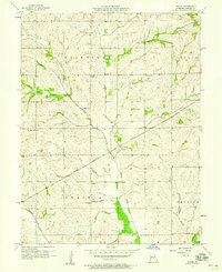
1957 Map of Roads
USGS Topo · Published 1958About this map
The rural settlement of Roads sits at the heart of this Carroll County landscape, serving as a hub for the surrounding agricultural townships of Fairfield, Leslie, Prairie, and Trotter. Mapped from 1948 aerial photography and field-checked in 1957, the area is defined by its deep spiritual and community roots, evidenced by the distribution of country churches including Mt Carmel Ch, Union Ch, and Antioch Ch.
Find a feature on this map
21 named features on this map. Tap any name to fly to it.
Don’t see what you’re looking for? This feature index may not catch every label — zoom into the map to look around manually.
Map Details
Editions of this 1957 Roads Map
2 editions found
Other maps of this area

1889 · Lexington
USGS Topo · 1:125,000

1924 · Dawn
USGS Topo · 1:62,500

1924 · Braymer
USGS Topo · 1:62,500

1950 · Coloma
USGS Topo · 1:24,000

1950 · Plymouth
USGS Topo · 1:24,000

1951 · Utica
USGS Topo · 1:62,500

1953 · Moberly
USGS Topo · 1:250,000

1954 · Moberly
USGS Topo · 1:250,000
1956 · Carrollton West
USGS Topo · 1:24,000

1957 · Moberly
USGS Topo · 1:250,000