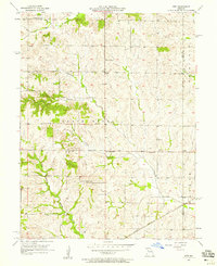
1957 Map of Stet
USGS Topo · Published 1958About this map
Wakenda Creek and its many tributaries, including Crabapple Creek and Cottonwood Creek, carve through the rolling agricultural landscape along the boundary of Ray and Carroll counties. In the late 1950s, this rural district was anchored by the small settlement of Stet, where the local Stet Sch and Bethany Ch served the surrounding farming community. The map reveals a dense network of country roads connecting isolated farmsteads to local landmarks like Log Cabin Station and the crossroads at Regal. To the south, the Chicago Burlington and Quincy railroad cuts across the terrain, providing a vital link for the region's produce. Local heritage is preserved in the numerous rural congregations, such as Little Union Ch and New Hope Ch, and the well-marked Penniston Cem, offering valuable data for genealogists and local historians tracing the families of the Grape Grove area.
Find a feature on this map
18 named features on this map. Tap any name to fly to it.
Don’t see what you’re looking for? This feature index may not catch every label — zoom into the map to look around manually.
Map Details
Editions of this 1957 Stet Map
2 editions found
Other maps of this area

1889 · Lexington
USGS Topo · 1:125,000

1924 · Dawn
USGS Topo · 1:62,500

1924 · Braymer
USGS Topo · 1:62,500

1950 · Plymouth
USGS Topo · 1:24,000

1951 · Utica
USGS Topo · 1:62,500

1953 · Moberly
USGS Topo · 1:250,000

1954 · Moberly
USGS Topo · 1:250,000

1957 · Moberly
USGS Topo · 1:250,000
1957 · Roads
USGS Topo · 1:24,000
1957 · Millville
USGS Topo · 1:24,000