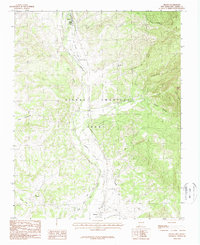
1983 Map of Brazos
USGS Topo · Published 1988About this map
The Tierra Amarilla Grant dominates this landscape in northern New Mexico, where the Rio Chama carves a fertile path through high-elevation terrain. In the early 1980s, the small settlements of Chama and Brazos served as primary hubs for the surrounding ranching and agricultural community. The map reveals a complex irrigation system vital to the region's survival, featuring the Barranco Ditch and Canones Ditch that draw water from the river to support local land use. To the east, the geography becomes increasingly complex with deep cuts like Cañonizaria Canyon and Nestor Canyon. This survey captures the transition from the river valley floor to the high-country flats, including landmarks such as Julian Flat and Dos Lomas, reflecting the enduring land grant traditions and the essential relationship between the alpine watershed and valley life.
Find a feature on this map
20 named features on this map. Tap any name to fly to it.
Don’t see what you’re looking for? This feature index may not catch every label — zoom into the map to look around manually.
Map Details
Editions of this 1983 Brazos Map
2 editions found
Other maps of this area

1918 · Tusas
USGS Topo · 1:125,000

1954 · Aztec
USGS Topo · 1:250,000

1955 · Chama
USGS Topo · 1:62,500

1955 · Cebolla
USGS Topo · 1:62,500

1955 · Brazos Peak
USGS Topo · 1:62,500

1955 · Tierra Amarilla
USGS Topo · 1:62,500

1958 · Aztec
USGS Topo · 1:250,000

1962 · Aztec
USGS Topo · 1:250,000

1965 · Aztec
USGS Topo · 1:250,000

1981 · Chama
USGS Topo · 1:100,000