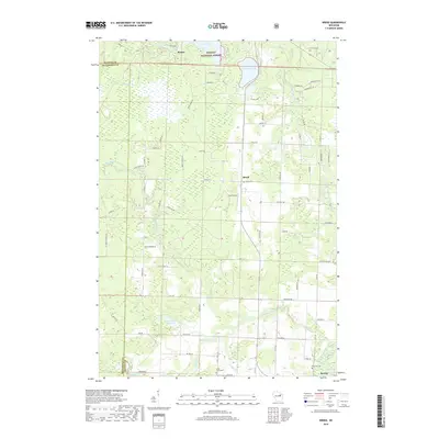
2018 Map of Breed
USGS Topo · Published 2018About this map
Nicolet National Forest dominates the northern reaches of this landscape, where the North Branch Oconto River and South Branch Oconto River wind through the terrain near Breed. The region is defined by its water and woods, from the larger Anderson Lake and Chute Pond to the smaller Wiscobee Lake. This 2018 survey reveals a network of rural roads such as Y Camp Rd and Weso Creek Rd that connect isolated settlements and local landmarks. Genealogists will find several key burial sites documented, including Union Cem, Saint John's Cem, and Riverside Cem near the southern edge by Suring. The presence of the small Piso Airport amidst the forest and fields highlights the area's rural infrastructure, while the border between Oconto and Menominee Counties marks the western boundary of this Oconto County study.
Find a feature on this map
75 named features on this map. Tap any name to fly to it.
Don’t see what you’re looking for? This feature index may not catch every label — zoom into the map to look around manually.
Map Details
Editions of this 2018 Breed Map
This is the sole edition of this map. No revisions or reprints were ever made.
Other maps of this area

1942 · Breed
USGS Topo · 1:48,000

1952 · Langlade
USGS Topo · 1:48,000

1952 · Mountain
USGS Topo · 1:48,000

1954 · Shawano
USGS Topo · 1:48,000

1954 · Iron Mountain
USGS Topo · 1:250,000

1955 · Green Bay
USGS Topo · 1:250,000

1956 · Gillett
USGS Topo · 1:62,500

1959 · Iron Mountain
USGS Topo · 1:250,000

1964 · Shawano
USGS Topo · 1:62,500
1973 · Mountain
USGS Topo · 1:24,000