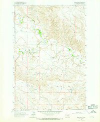
1963 Map of Breed Spring
USGS Topo · Published 1966About this map
Flatwillow Creek meanders through this landscape in Petroleum County, defining the drainage patterns of the central territory. Surveyed in the early 1960s, the map reveals a remote section of Montana where life revolved around scarce water sources like Breed Spring. The terrain is marked by deep coulees, including Gorman Coulee in the north and Anderson Coulee to the south, which serve as natural landmarks across the open range. In the northwest corner, Box Elder Creek cuts through the high ground, while the southern boundary is shaped by the headwaters of North Maginnis Creek. This survey captures the rural character of the Big Sky Country before significant modern development, documenting the specific locations of named springs and seasonal waterways essential for ranching and land management in the mid-twentieth century.
Find a feature on this map
8 named features on this map. Tap any name to fly to it.
Don’t see what you’re looking for? This feature index may not catch every label — zoom into the map to look around manually.
Map Details
Editions of this 1963 Breed Spring Map
This is the sole edition of this map. No revisions or reprints were ever made.
Other maps of this area

1954 · Jordan
USGS Topo · 1:250,000

1954 · Forsyth
USGS Topo · 1:250,000

1954 · Roundup
USGS Topo · 1:250,000

1954 · Lewistown
USGS Topo · 1:250,000

1956 · Jordan
USGS Topo · 1:250,000

1957 · Forsyth
USGS Topo · 1:250,000

1958 · Jordan
USGS Topo · 1:250,000

1958 · Roundup
USGS Topo · 1:250,000

1958 · Forsyth
USGS Topo · 1:250,000

1959 · Lewistown
USGS Topo · 1:250,000