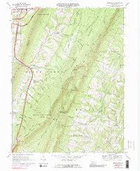
1969 Map of Breezewood
USGS Topo · Published 1989About this map
Breezewood serves as a major transportation hub where the Pennsylvania Turnpike meets regional routes, a crossroads character defined by a series of numbered interchanges including Interchange 28 and Interchange 29. The landscape is dominated by the dramatic north-south ridges of Rays Hill and Sideling Hill, which force the road network into narrow gaps and valleys. While the turnpike corridor represents modern transit, the surrounding hollows like Marshall Hollow and Wildcat Hollow preserve an older pattern of Pennsylvania settlement.
Find a feature on this map
63 named features on this map. Tap any name to fly to it.
Don’t see what you’re looking for? This feature index may not catch every label — zoom into the map to look around manually.
Map Details
Editions of this 1969 Breezewood Map
This is the sole edition of this map. No revisions or reprints were ever made.
Other maps of this area

1900 · Everett
USGS Topo · 1:62,500

1902 · Everett
USGS Topo · 1:62,500

1925 · Needmore
USGS Topo · 1:48,000

1927 · Clearville
USGS Topo · 1:48,000

1930 · Broad Top
USGS Topo · 1:62,500

1931 · Clearville
USGS Topo · 1:62,500

1933 · Broad Top
USGS Topo · 1:62,500

1935 · Needmore
USGS Topo · 1:62,500

1939 · Needmore
USGS Topo · 1:62,500

1944 · Clearville
USGS Topo · 1:62,500
Featured Places
- Gapsville, East Providence Township
- East Providence Township, PA
- Licking Creek Township, PA
- Akersville, Brush Creek Township
- Sipes Mill, Belfast Township