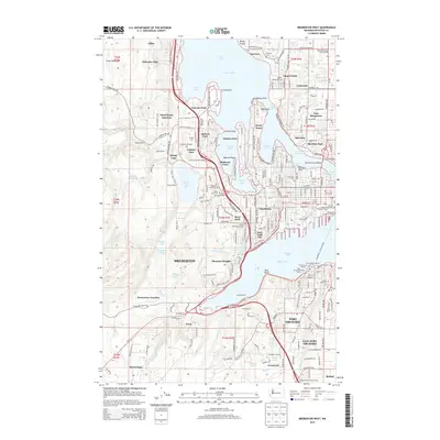
2014 Map of Bremerton West
USGS Topo · Published 2014About this map
Sinclair Inlet and the complex waterways of Puget Sound define this coastal landscape, where the urban centers of Bremerton and Port Orchard face one another across the water. The geography is characterized by deep indentations like Dyes Inlet, Ostrich Bay, and Phinney Bay, creating a shoreline of numerous points and coves including Erlands Point and Rocky Point. The infrastructure is heavily influenced by the maritime and military presence, evidenced by Navy Yard City and the Bremerton Ferry Landing. Inland, the terrain rises toward Eldorado Hills and contains several bodies of water such as Kitsap Lake and Jarstad Lake. Local history is preserved in several significant sites including Woodlawn Memorial Park, Forest Lawn Cem, and Ivy Green Cem, while educational and institutional anchors like Olympic Coll and Jackson Park serve the growing residential communities of Tracyton and East Bremerton.
Find a feature on this map
129 named features on this map. Tap any name to fly to it.
Don’t see what you’re looking for? This feature index may not catch every label — zoom into the map to look around manually.
Map Details
Editions of this 2014 Bremerton West Map
This is the sole edition of this map. No revisions or reprints were ever made.
Other maps of this area

1936 · Point Misery
USGS Topo · 1:62,500

1937 · Port Orchard
USGS Topo · 1:62,500

1938 · Allyn
USGS Topo · 1:62,500

1940 · Point Misery
USGS Topo · 1:62,500

1942 · Gig Harbor
USGS Topo · 1:62,500

1943 · Gig Harbor
USGS Topo · 1:62,500

1953 · Seabeck
USGS Topo · 1:24,000

1953 · Poulsbo
USGS Topo · 1:24,000

1953 · Burley
USGS Topo · 1:24,000

1953 · Bremerton West
USGS Topo · 1:24,000
Featured Places
- Bremerton, WA
- Port Orchard, WA
- Tracyton, WA
- East Port Orchard, Port Orchard
- Erlands Point-Kitsap Lake, WA