
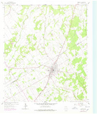
1962 Map of Bremond
USGS Topo · Published 1964About this map
Bremond serves as a prominent rail hub in the early 1960s, defined by the diagonal sweep of the Southern Pacific railroad through the heart of the town. The settlement displays a established community structure with several religious and educational centers, including St Mary Ch, Pleasant Grove Ch, and a local High Sch with its adjacent Athletic Field. Local history researchers will find a significant concentration of burial sites nearby, such as St Mary Cem, Cloverleaf Rest Cem, and the Harper Cem.
Find a feature on this map
30 named features on this map. Tap any name to fly to it.
Don’t see what you’re looking for? This feature index may not catch every label — zoom into the map to look around manually.
Map Details
Editions of this 1962 Bremond Map
2 editions found
Other maps of this area

1954 · Waco
USGS Topo · 1:250,000

1955 · Waco
USGS Topo · 1:250,000

1957 · McClanahan
USGS Topo · 1:24,000

1961 · Baileyville
USGS Topo · 1:24,000

1962 · Hammond
USGS Topo · 1:24,000

1962 · Reagan
USGS Topo · 1:24,000

1962 · Petteway
USGS Topo · 1:24,000
1962 · Owensville
USGS Topo · 1:24,000

1965 · Kosse West
USGS Topo · 1:24,000
1966 · Kosse East
USGS Topo · 1:24,000