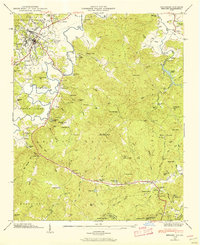
1945 Map of Brevard
USGS Topo · Published 1956About this map
Brevard and its surrounding mountain gaps are captured here following a mid-1940s field examination by the Tennessee Valley Authority. The French Broad River snakes through the valley, past the campus of Brevard College and the industrial activity of the Southern RR. The landscape is a patchwork of early mountain education and spiritual life, featuring the Little River School and numerous small congregations like Carr Hill Ch and Mitchell Chapel. Outside the town center, the terrain rises into the Pisgah National Forest, where infrastructure like the Lookout Tower on Rich Mtn and the Power Plant near Cascade Lake reveal the mid-century management of the region's water and timber resources. Dozens of family-named cemeteries, including Gillespie Cem and Holden Cem, provide significant grounding for genealogical research in this part of Transylvania County.
Find a feature on this map
110 named features on this map. Tap any name to fly to it.
Don’t see what you’re looking for? This feature index may not catch every label — zoom into the map to look around manually.
Map Details
Editions of this 1945 Brevard Map
2 editions found
Other maps of this area

1905 · Pisgah
USGS Topo · 1:125,000

1906 · Pisgah
USGS Topo · 1:125,000

1935 · Brevard
USGS Topo · 1:24,000

1935 · Eastatoe Gap
USGS Topo · 1:24,000

1935 · Standingstone Mtn.
USGS Topo · 1:24,000

1935 · Horse Shoe
USGS Topo · 1:24,000

1935 · Rosman
USGS Topo · 1:24,000

1935 · Table Rock
USGS Topo · 1:24,000

1935 · Shining Rock
USGS Topo · 1:24,000

1935 · Pisgah Forest
USGS Topo · 1:24,000