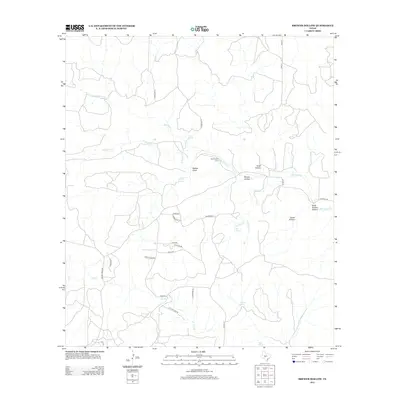
2012 Map of Brewer Hollow
USGS Topo · Published 2012About this map
Bannowsky Cem serves as a quiet landmark in this landscape defined by the drainage of Big Saline Cr and its numerous seasonal tributaries. The geography is carved into distinct basins and draws, including Brewer Hollow, Coon Hollow, and Walton Draw, which feed the water system that sustains local ranching. The importance of reliable water in this part of Kimble County is evidenced by the density of named water sources such as Iona Springs, Walton Spring, Elm Spring, and Cracked Spring. A network of rural routes, including Co RD-372 and Co RD-373, connects these remote points, while curiously named local roads like Bourbon St and Whiskey Rd hint at the personalities and history of the local landholders during the early 21st century.
Find a feature on this map
35 named features on this map. Tap any name to fly to it.
Don’t see what you’re looking for? This feature index may not catch every label — zoom into the map to look around manually.
Map Details
Editions of this 2012 Brewer Hollow Map
This is the sole edition of this map. No revisions or reprints were ever made.
Other maps of this area

1954 · Llano
USGS Topo · 1:250,000

1955 · Llano
USGS Topo · 1:250,000

1956 · Llano
USGS Topo · 1:250,000

1968 · London
USGS Topo · 1:24,000

1968 · Yates
USGS Topo · 1:24,000

1970 · Julio Draw
USGS Topo · 1:24,000

1970 · Brewer Hollow
USGS Topo · 1:24,000

1970 · Elm Slough
USGS Topo · 1:24,000

1970 · East Elm Creek
USGS Topo · 1:24,000
1970 · Hext
USGS Topo · 1:24,000