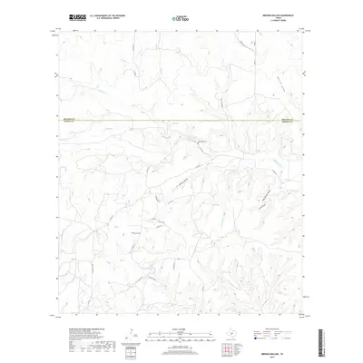
2019 Map of Brewer Hollow
USGS Topo · Published 2019About this map
Barinowsky Cem sits at the heart of this landscape along the boundary of Menard and Kimble counties, marking a point of generational history in the Texas Hill Country. The terrain is defined by a dense network of seasonal watercourses and drainages, most notably Big Saline Cr and its southern fork, S Saline Cr. The frequency of named water sources like Iona Springs, Walton Spring, and Scott Springs underscores the importance of reliable water in this ranching environment. Local landmarks follow a pattern of family and geographic naming, such as Brewer Hollow, Coon Hollow, and Walton Draw. This modern survey details a rural area primarily accessed by county roads and private lanes, including Co Rd 370 and Gentry Creek Rd, which navigate the complex system of draws and hollows that feed into the larger creek systems.
Find a feature on this map
36 named features on this map. Tap any name to fly to it.
Don’t see what you’re looking for? This feature index may not catch every label — zoom into the map to look around manually.
Map Details
Editions of this 2019 Brewer Hollow Map
This is the sole edition of this map. No revisions or reprints were ever made.
Other maps of this area

1954 · Llano
USGS Topo · 1:250,000

1955 · Llano
USGS Topo · 1:250,000

1956 · Llano
USGS Topo · 1:250,000

1968 · London
USGS Topo · 1:24,000

1968 · Yates
USGS Topo · 1:24,000

1970 · Julio Draw
USGS Topo · 1:24,000

1970 · Brewer Hollow
USGS Topo · 1:24,000

1970 · Elm Slough
USGS Topo · 1:24,000

1970 · East Elm Creek
USGS Topo · 1:24,000
1970 · Hext
USGS Topo · 1:24,000