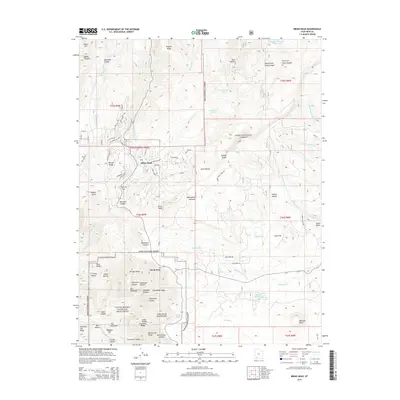
2014 Map of Brian Head
USGS Topo · Published 2014About this map
Brian Head sits at the heart of this 2014 survey, illustrating the high-altitude development of this mountain community on the Markagunt Plateau. The map shows a transition from the established settlement near Bear Flat to the protected natural landscapes of the Dixie National Forest. To the south, the dramatic geology of the Cedar Breaks National Monument is captured in detail, including the Cedar Breaks Amphitheater and the North View overlook. The drainage patterns of the plateau are defined by various forks and creeks, such as Mammoth Cr and Parowan Cr, which originate in these highlands. The presence of developed infrastructure like W Ski View Dr and Tobagan Ln alongside remote trails like the Brian Head Peak Trl reflects the dual nature of the region as both a seasonal resort destination and a critical wilderness preserve.
Find a feature on this map
92 named features on this map. Tap any name to fly to it.
Don’t see what you’re looking for? This feature index may not catch every label — zoom into the map to look around manually.
Map Details
Editions of this 2014 Brian Head Map
This is the sole edition of this map. No revisions or reprints were ever made.
Other maps of this area

1886 · Kanab
USGS Topo · 1:250,000

1953 · Cedar City
USGS Topo · 1:250,000

1958 · Cedar City
USGS Topo · 1:250,000

1958 · Cedar Breaks
USGS Topo · 1:62,500

1958 · Panguitch Lake
USGS Topo · 1:62,500

1962 · Cedar City
USGS Topo · 1:250,000
1971 · Summit
USGS Topo · 1:24,000

1971 · Parowan
USGS Topo · 1:24,000
1971 · Red Creek Reservoir
USGS Topo · 1:24,000

1980 · Panguitch
USGS Topo · 1:100,000