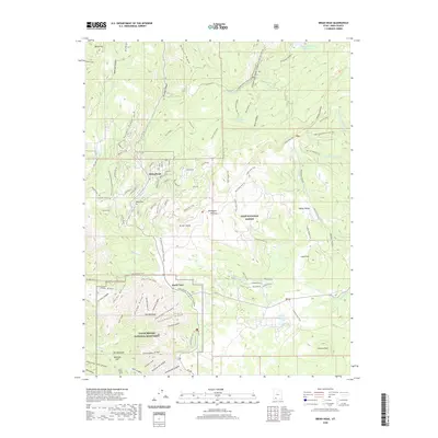
2020 Map of Brian Head
USGS Topo · Published 2020About this map
The Markagunt Plateau is the dominant geographical feature of this high-altitude landscape, where the resort community of Brian Head is established among the ridges and drainages. The map details the complex intersection of federal lands, including the northern portions of Cedar Breaks National Monument and the surrounding Dixie National Forest. This modern survey illustrates how recreation has shaped the modern topography, documenting a vast network of winter and summer trails such as the Brian Head Snowmobile Trail and the Sidney Peak Trail. In the southern reaches, striking geological formations are marked by Bristlecone Ridge, Columbine Ridge, and the Chessmen Ridge, which overlook deep-cut features like Labyrinth Canyon and Ashdown Cr. Settlement remains sparse outside the primary hub, with smaller named locales like Bear Flat, North View, and The Meadows providing reference points for researchers tracking land use and property boundaries near the Yankee Meadows Reservoir.
Find a feature on this map
104 named features on this map. Tap any name to fly to it.
Don’t see what you’re looking for? This feature index may not catch every label — zoom into the map to look around manually.
Map Details
Editions of this 2020 Brian Head Map
This is the sole edition of this map. No revisions or reprints were ever made.
Other maps of this area

1886 · Kanab
USGS Topo · 1:250,000

1953 · Cedar City
USGS Topo · 1:250,000

1958 · Cedar City
USGS Topo · 1:250,000

1958 · Cedar Breaks
USGS Topo · 1:62,500

1958 · Panguitch Lake
USGS Topo · 1:62,500

1962 · Cedar City
USGS Topo · 1:250,000
1971 · Summit
USGS Topo · 1:24,000

1971 · Parowan
USGS Topo · 1:24,000
1971 · Red Creek Reservoir
USGS Topo · 1:24,000

1980 · Panguitch
USGS Topo · 1:100,000