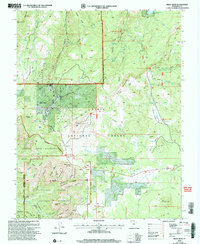
2002 Map of Brian Head
USGS Topo · Published 2005About this map
High-altitude resort development and protected wilderness define this high plateau landscape at the start of the 21st century. The settlement of Brian Head serves as the hub for outdoor recreation, featuring numerous Ski Lift lines that climb toward Mammoth Summit. To the south, the intricate erosional features of Cedar Breaks National Monument reveal a complex system of ridges and canyons, including Chessman Ridge and Labyrinth Canyon. This survey illustrates the delicate balance between active resource extraction, seen at the Gravel Pit and Cinder Pit, and conservation in the Ashdown Gorge Wilderness. Water management is prominent through the Yankee Meadows Reservoir and high-elevation bodies like Hendrickson Lake and Alpine Pond. The vast reach of the Dixie National Forest encompasses geological landmarks like Sidney Peaks and the sweeping Sidney Valley, while established routes like the Marathon trail provide access through the deep timber of Dark Hollow.
Find a feature on this map
58 named features on this map. Tap any name to fly to it.
Don’t see what you’re looking for? This feature index may not catch every label — zoom into the map to look around manually.
Map Details
Editions of this 2002 Brian Head Map
This is the sole edition of this map. No revisions or reprints were ever made.
Other maps of this area

1886 · Kanab
USGS Topo · 1:250,000

1953 · Cedar City
USGS Topo · 1:250,000

1958 · Cedar City
USGS Topo · 1:250,000

1958 · Cedar Breaks
USGS Topo · 1:62,500

1958 · Panguitch Lake
USGS Topo · 1:62,500

1962 · Cedar City
USGS Topo · 1:250,000
1971 · Summit
USGS Topo · 1:24,000

1971 · Parowan
USGS Topo · 1:24,000
1971 · Red Creek Reservoir
USGS Topo · 1:24,000

1980 · Panguitch
USGS Topo · 1:100,000