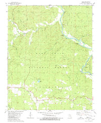
1979 Map of Briar
USGS Topo · Published 1980About this map
The Current River snakes through the eastern half of this terrain, its course defined by a series of distinctive water features such as Round Bay, Peter Bay, and the interestingly named Bugger Boo Bay. This 1979 survey captures the rugged landscape within the Mark Twain National Forest, where deep hollows like Jinks Hollow and Whetstone Hollow cut through the timberland. The small settlement of Briar serves as the primary point of human occupancy, while the land is dotted with family-named landmarks and resting places, including Bennett Cem and Rosson Cem. The development of the area for leisure is evident in the multiple designated sites along the riverbank, from the Compton Recreation Area to the Float Camp Recreation Area, suggesting a region transitioning from isolated timber and farm plots toward managed forest and river-based recreation.
Find a feature on this map
42 named features on this map. Tap any name to fly to it.
Don’t see what you’re looking for? This feature index may not catch every label — zoom into the map to look around manually.
Map Details
Editions of this 1979 Briar Map
This is the sole edition of this map. No revisions or reprints were ever made.
Other maps of this area

1939 · Doniphan
USGS Topo · 1:62,500

1941 · Gatewood
USGS Topo · 1:62,500

1944 · Van Buren
USGS Topo · 1:62,500

1944 · Grandin
USGS Topo · 1:62,500

1945 · Doniphan
USGS Topo · 1:62,500

1945 · Gatewood
USGS Topo · 1:62,500

1946 · Grandin
USGS Topo · 1:62,500

1946 · Van Buren
USGS Topo · 1:62,500

1957 · Poplar Bluff
USGS Topo · 1:250,000

1959 · Poplar Bluff
USGS Topo · 1:250,000