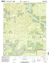
1997 Map of Briar
USGS Topo · Published 1999About this map
The Current River winds through the heart of the Mark Twain National Forest in this late-1990s survey of southern Missouri. The landscape is defined by deep drainages and family-named hollows, including Jinks Hollow, Possum Hollow, and Whetstone Hollow, which feed into the river system. At the river's edge, distinctive river features like Hargus Eddy and the high point of Deer Leap mark the recreation-rich terrain, supported by the Float Camp and various boat access points. In the southern portion of the quadrangle, the community of Briar serves as a local hub near Tattle Creek. Genealogists will find significant value in the documentation of numerous local burial sites such as Bennett Cemetery, Rosson Cemetery, and Shirley Cemetery, as well as the Wilson Church, which provide a clear record of the area's rural settlement pattern.
Find a feature on this map
44 named features on this map. Tap any name to fly to it.
Don’t see what you’re looking for? This feature index may not catch every label — zoom into the map to look around manually.
Map Details
Editions of this 1997 Briar Map
This is the sole edition of this map. No revisions or reprints were ever made.
Other maps of this area

1939 · Doniphan
USGS Topo · 1:62,500

1941 · Gatewood
USGS Topo · 1:62,500

1944 · Van Buren
USGS Topo · 1:62,500

1944 · Grandin
USGS Topo · 1:62,500

1945 · Doniphan
USGS Topo · 1:62,500

1945 · Gatewood
USGS Topo · 1:62,500

1946 · Grandin
USGS Topo · 1:62,500

1946 · Van Buren
USGS Topo · 1:62,500

1957 · Poplar Bluff
USGS Topo · 1:250,000

1959 · Poplar Bluff
USGS Topo · 1:250,000