1893 Map of Briceville
USGS Topo · Published 1893About this map
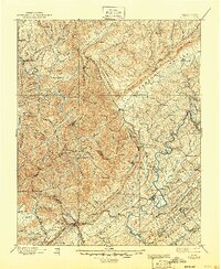
Cumberland Mountain dominates this late-nineteenth-century landscape, carving a massive diagonal across the terrain and separating the industrial mining corridor from the broad Powell Valley. The era's coal economy is evident in the dense cluster of settlements like Briceville, Coal Creek, and Caryville positioned along the base of Walden Ridge. The complex geography of the region is further defined by Black Oak Ridge and Chestnut Ridge, which frame the lower valley where the Clinton county seat and Andersonville are established. Connectivity in this period relied heavily on the Knoxville and Ohio R. R. and the Tennessee R. R., which navigated the narrow gaps and valleys to reach remote outposts such as Huntsville. For family historians, the map preserves numerous small communities and landmarks like Hatmaker, Whitman, and Blacks Ford that reflect the early social and industrial fabric of Campbell and Anderson counties.
Find a feature on this map
139 named features on this map. Tap any name to fly to it.
Don’t see what you’re looking for? This feature index may not catch every label — zoom into the map to look around manually.
Map Details
Editions of this 1893 Briceville Map
This is the sole edition of this map. No revisions or reprints were ever made.
Historical Maps of Broadacres Through Time
3 maps found