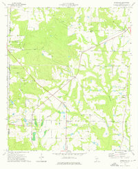
1974 Map of Bridgeboro
USGS Topo · Published 1976About this map
Bridgeboro serves as a focal point for this rural landscape in Worth County, where the Georgia Northern railroad defines the local transport corridor. The map reveals a deeply rooted community structure, evidenced by the numerous country churches like Hopewell Ch and Mt Pisgah Ch that anchor small settlements. Waterways such as the Ochlockonee River and Little Ochlockonee River dominate the eastern reaches, while the western side is marked by the distinct boundary between Dougherty and Worth counties. For genealogists, the map provides precise locations for family-named landmarks and resting places, including Parker Cem and Parkerville Cem. The transition from the more developed area around Crestwood to the agricultural expanses near Alfords and Gordy illustrates the mid-1970s land-use patterns in this part of South Georgia.
Find a feature on this map
32 named features on this map. Tap any name to fly to it.
Don’t see what you’re looking for? This feature index may not catch every label — zoom into the map to look around manually.
Map Details
Editions of this 1974 Bridgeboro Map
2 editions found
Other maps of this area

1953 · Dothan
USGS Topo · 1:250,000

1953 · Waycross
USGS Topo · 1:250,000

1954 · Dothan
USGS Topo · 1:250,000

1955 · Dothan
USGS Topo · 1:250,000

1956 · Albany East
USGS Topo · 1:24,000

1956 · Baconton
USGS Topo · 1:62,500

1956 · Sylvester
USGS Topo · 1:62,500

1956 · Doerun
USGS Topo · 1:62,500

1956 · Albany
USGS Topo · 1:62,500

1958 · Waycross
USGS Topo · 1:250,000