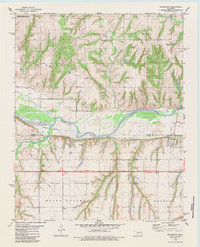
1979 Map of Bridgeport
USGS Topo · Published 1984About this map
The Canadian River carves a significant path through this landscape, serving as the physical boundary between Blaine and Caddo counties. This late 1970s survey captures the settlement of Bridgeport positioned along the southern banks, where the Chicago Rock Island and Pacific railroad follows the river's course. The topography reveals a mix of flat valley lands and deeply incised drainage features such as Fivemile Canyon and White Canyon. Local infrastructure and community life are grounded in landmarks like Pleasant Ridge Ch and Bethel Ch, alongside several Gas Wells that point to the region's energy resources. To the northwest, the American Horse Lake State Hunting and Fishing Area provides a designated space for conservation and recreation amidst the rural terrain of Long Boundary and Mound Valley.
Find a feature on this map
24 named features on this map. Tap any name to fly to it.
Don’t see what you’re looking for? This feature index may not catch every label — zoom into the map to look around manually.
Map Details
Editions of this 1979 Bridgeport Map
2 editions found
Other maps of this area

1942 · Geary
USGS Topo · 1:62,500

1951 · Binger
USGS Topo · 1:62,500

1955 · Clinton
USGS Topo · 1:250,000

1957 · Clinton
USGS Topo · 1:250,000

1961 · Eakly
USGS Topo · 1:62,500

1964 · Weatherford
USGS Topo · 1:62,500

1979 · Hinton
USGS Topo · 1:24,000
1979 · Geary North
USGS Topo · 1:24,000
1979 · Geary South
USGS Topo · 1:24,000

1979 · Greenfield
USGS Topo · 1:24,000