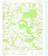
1960 Map of Bridgeport East
USGS Topo · Published 1978About this map
The West Fork Trinity River carves a winding path through this Wise County landscape, defining the local geography alongside the Chicago Rock Island and Pacific railroad. Centered on the community of Paradise, the map reveals a mid-century rural economy shifting toward energy production as numerous Gas Wells dot the terrain, culminating in the expansive Paradise Gas Field to the south. Local history is anchored by essential institutions like Cuba Ch, the Paradise School, and several family and community burial grounds, including Valley View Cemetery and Prescott Cemetery. To the northwest, the edge of Bridgeport begins its urban expansion, marked by a 1970s revision. The hydrology is particularly detailed, showing how tributaries like Big Sandy Creek, Waggoner Branch, and Rush Creek feed the Trinity River system.
Find a feature on this map
18 named features on this map. Tap any name to fly to it.
Don’t see what you’re looking for? This feature index may not catch every label — zoom into the map to look around manually.
Map Details
Editions of this 1960 Bridgeport East Map
2 editions found
Other maps of this area

1924 · Sunset 4-d
USGS Topo · 1:48,000

1930 · Boyd
USGS Topo · 1:62,500

1954 · Sherman
USGS Topo · 1:250,000

1958 · Sherman
USGS Topo · 1:250,000

1960 · Bridgeport West
USGS Topo · 1:24,000

1960 · Bridgeport East
USGS Topo · 1:24,000

1960 · Decatur
USGS Topo · 1:24,000

1960 · Boyd
USGS Topo · 1:24,000

1960 · Cottondale
USGS Topo · 1:24,000
1960 · Boonsville
USGS Topo · 1:24,000