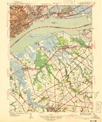
1940 Map of Bridgeport
USGS Topo · Published 1940About this map
Industrial activity along the Delaware River defines this 1940 survey of the borderlands between Pennsylvania and New Jersey. The Pennsylvania shore is heavily developed, anchored by the massive Locomotive Works near Eddystone and the Hog Island Shipyard (Abandoned) downstream. This heavy manufacturing hub contrasts sharply with the tidal marshes and agricultural landscape of Gloucester County, New Jersey. In the township of Greenwich and Logan, life is organized around small settlements like Bridgeport and Gibbstown, where the Pennsylvania and Reading railroads intersect the truck farms of the interior.
Find a feature on this map
63 named features on this map. Tap any name to fly to it.
Don’t see what you’re looking for? This feature index may not catch every label — zoom into the map to look around manually.
Map Details
Editions of this 1940 Bridgeport Map
This is the sole edition of this map. No revisions or reprints were ever made.
Other maps of this area

1890 · Salem
USGS Topo · 1:62,500

1890 · Glassboro
USGS Topo · 1:62,500

1891 · Philadelphia
USGS Topo · 1:62,500

1894 · Chester
USGS Topo · 1:62,500

1894 · Philadelphia
USGS Topo · 1:62,500

1896 · Philadelphia
USGS Topo · 1:62,500

1896 · Chester
USGS Topo · 1:62,500

1898 · Salem
USGS Topo · 1:62,500

1898 · Glassboro
USGS Topo · 1:62,500

1898 · Chester
USGS Topo · 1:62,500