
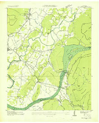
1936 Map of Bridgeport
USGS Topo · Published 1936About this map
The Tennessee River corridor in 1936 is a landscape in transition, captured just as the Tennessee Valley Authority planned for the inundation of the valley floor. The map depicts the Guntersville Reservoir (Proposed) outline, tracing how the rising waters would soon surround Long Island and alter the river's path. At this moment, traditional river crossings like the Island Creek Ferry and Reese Ferry are still active, serving as vital links for the rural population in Brown Valley and Jaw Valley.
Find a feature on this map
59 named features on this map. Tap any name to fly to it.
Don’t see what you’re looking for? This feature index may not catch every label — zoom into the map to look around manually.
Map Details
Editions of this 1936 Bridgeport Map
This is the sole edition of this map. No revisions or reprints were ever made.
Other maps of this area

1886 · Stevenson
USGS Topo · 1:125,000

1892 · Stevenson
USGS Topo · 1:125,000

1895 · Stevenson
USGS Topo · 1:125,000

1895 · Sewanee
USGS Topo · 1:125,000

1936 · Trenton
USGS Topo · 1:24,000

1936 · Shellmound
USGS Topo · 1:24,000

1936 · Orme
USGS Topo · 1:24,000

1936 · Flat Rock
USGS Topo · 1:24,000

1936 · Stevenson
USGS Topo · 1:24,000
1936 · Sequatchie
USGS Topo · 1:24,000