
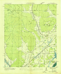
1936 Map of Orme
USGS Topo · Published 1936About this map
Cumberland Plateau industry and rural life are documented in this 1936 survey, showing the mining operations that defined the local economy. The settlement of Orme sits at the terminus of the N C & St L Ry and an incline, serving as a hub for the extraction of resources from the Battle Creek Mines and Bolten Mines. These industrial sites are tucked into narrow drainages like Widows Creek and Wildcat Turnpike, illustrating the complex logistical network required to transport coal from the high ridges.
Find a feature on this map
40 named features on this map. Tap any name to fly to it.
Don’t see what you’re looking for? This feature index may not catch every label — zoom into the map to look around manually.
Map Details
Editions of this 1936 Orme Map
This is the sole edition of this map. No revisions or reprints were ever made.
Other maps of this area

1886 · Stevenson
USGS Topo · 1:125,000

1892 · Stevenson
USGS Topo · 1:125,000

1895 · Stevenson
USGS Topo · 1:125,000

1895 · Sewanee
USGS Topo · 1:125,000

1936 · Sewanee
USGS Topo · 1:24,000

1936 · Bridgeport
USGS Topo · 1:24,000

1936 · Sinking Cove
USGS Topo · 1:24,000

1936 · Monteagle
USGS Topo · 1:24,000

1936 · White City
USGS Topo · 1:24,000
1936 · Doran Cove
USGS Topo · 1:24,000