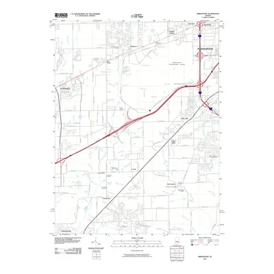
2010 Map of Bridgeport
USGS Topo · Published 2010About this map
The Indianapolis International Airport and its complex network of perimeter roads dominate the central landscape of this 2010 survey. Just to the west, the unincorporated community of Bridgeport and the nearby crossroads of Six Points sit at the edge of the airport's expansive grounds. The southern portion of the quadrangle retains a more traditional settlement pattern, anchored by the villages of West Newton, Camby, and Friendswood. Numerous family and denominational burial grounds, including the Bridgeport Friends Cemetery, Bethel Methodist Cemetery, and Lick Branch Cemetery, are scattered throughout the region, offering a rich resource for genealogical research. The natural drainage of the area is defined by East Fork White Lick Creek and Clarks Creek, which wind through the terrain alongside modern transportation corridors like Bucbas Rd and various interstate ramps that connect the suburbs of Plainfield and Indianapolis to the larger metropolitan area.
Find a feature on this map
103 named features on this map. Tap any name to fly to it.
Don’t see what you’re looking for? This feature index may not catch every label — zoom into the map to look around manually.
Map Details
Editions of this 2010 Bridgeport Map
This is the sole edition of this map. No revisions or reprints were ever made.
Other maps of this area

1948 · Maywood
USGS Topo · 1:24,000

1948 · Indianapolis West
USGS Topo · 1:24,000

1952 · Bargersville
USGS Topo · 1:24,000

1953 · Bridgeport
USGS Topo · 1:24,000

1953 · Brownsburg
USGS Topo · 1:24,000

1953 · Plainfield
USGS Topo · 1:24,000

1953 · Clermont
USGS Topo · 1:24,000

1953 · Indianapolis
USGS Topo · 1:250,000

1955 · Mooresville West
USGS Topo · 1:24,000

1955 · Mooresville East
USGS Topo · 1:24,000