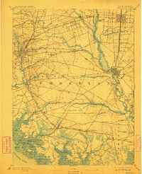
1894 Map of Bridgeton
USGS Topo · Published 1910About this map
Cohansey Creek and the Maurice River define the industrial and maritime layout of Cumberland County during this late 19th-century period. The map reveals a dense network of glass-manufacturing centers and agricultural hubs, with Bridgeton and Millville serving as primary anchors. The interior landscape is marked by smaller, specialized settlements like the Jewish agricultural colony of Carmel and established communities such as Gouldtown and Fairton.
Find a feature on this map
83 named features on this map. Tap any name to fly to it.
Don’t see what you’re looking for? This feature index may not catch every label — zoom into the map to look around manually.
Map Details
Editions of this 1894 Bridgeton Map
4 editions found

Other maps of this area

1888 · Dennisville
USGS Topo · 1:62,500

1890 · Hammonton
USGS Topo · 1:62,500

1890 · Salem
USGS Topo · 1:62,500

1890 · Tuckahoe
USGS Topo · 1:62,500

1890 · Maurice Cove
USGS Topo · 1:62,500

1890 · Bay Side
USGS Topo · 1:62,500

1890 · Bridgeton
USGS Topo · 1:62,500

1890 · Glassboro
USGS Topo · 1:62,500

1891 · Maurice Cove
USGS Topo · 1:62,500

1893 · Tuckahoe
USGS Topo · 1:62,500